Details, details, details

A. F. Church published a topographical map of each county in Nova Scotia between 1865 and 1888.
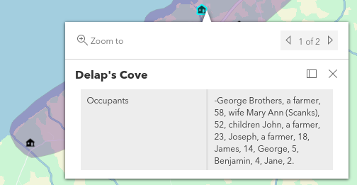
These maps feature detailed plans of the various census districts and townships including location of buildings, names of occupants, transportation routes and various geographical markings.

On the simplified version of the Delaps Cove map on the right, notice the map pin in the circle.
When local historian Ian Lawrence researched his book, Black Loyalists of Annapolis County, the A.F. Church maps proved invaluable. Mapannapolis hosts a storymap created from of Ian’s work here.
Thanks to the A.F. Church maps, and Ian’s in-depth research, we have a better understanding of Annapolis County’s early Black Loyalist families.
Mapannapolis attended the A.F. Church Historical Maps Specialist Workshop in the late summer of 2021 at the Millbrook Room in the Rath Eastlink Community Centre, in Truro.

Mapannapolis offers a storymap detailing black Loyalist settlement in Annapolis County here.