Beyond the surface
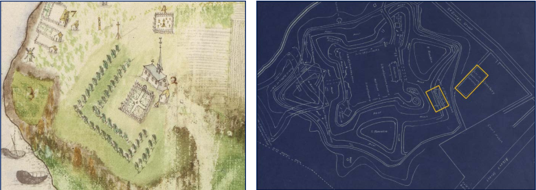
Details, details, details. The map of the left, from 1686, is of the French fort at Annapolis Royal with the parish church of St. Jean-Baptiste clearly shown.
Historic mapping indicates the church was situated south of the enclosed Acadian cemetery, both of which are shown superimposed on a much later map of the fortress as yellow outlines.
Where do you get your inspiration?
Artists over the ages have one thing in common, and it’s that question.
“ The inspiration for my work was from a research project entitled the “Acadian Ancestral Project” by Mapannapolis using a series of modern technologies to discover “What Lies Beneath” the Garrison Graveyard at Fort Anne Historic Site.
A subsurface GPR image of what had been common knowledge, the site of the Acadian graveyard at Fort Anne, even though the wooden crosses marking them are long gone.
“Based on the results of the GPR (ground-penetrating radar) survey, Boreas Heritage identified 19 subsurface anomalies, relatively consistent in size, depth, and orientation. All were located at a depth of approximately 1 metre below the ground surface, representing a pattern of spaced anomolies alighned north-south and oriented east-west.”
“My intent was to use the GPR and LiDAR composite images as a resource, and take them into spiritual and transformative encounters. My painting process and explorations are a visual play of pushing, pulling, and holding the dynamics of painted movement by using oppositional counterpoints. The intent of my work/paintings has always been for the viewer to “fall in and drown in the work” and “see things beyond the surface of the paintings”.”
Inspiration for Wayne’s work, our story map An Acadian Ancestry Project: What Lies Beneath, may be found here.


